Linde Material Handling presented new modules for its “connect” fleet management system at the Intralogistics Safety Forum, held in Aschaffenburg on September 20, 2018 for the first time. The digital applications “Zone Intelligence” and “Truck Mapping” utilize various technologies to make the use of industrial trucks even safer and more transparent.
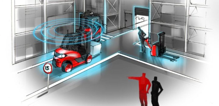
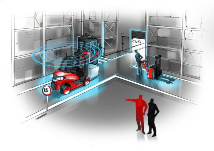
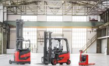
The new “connect” module “Zone Intelligence”, which will be available both as a retrofit solution and ex works from the beginning of next year, is another significant step towards greater safety in halls and other indoor environments. In spite of comprehensive safety equipment, the use of industrial trucks still involves certain risks. This is not least due to the fact that the drivers themselves can determine the speed at which they travel and to what extent they reduce this speed at crossings or in narrow aisles. The same applies to driving with the lift mast raised too far. Collisions with roller shutters or ceiling supports caused by carelessness result in damage amounting to millions of euros every year. Linde Material Handling has developed its new sensor-based assistance system to mitigate these potentially hazardous and costly situations. It allows fleet operators to define specific zones in warehouses and production areas in which the truck speed is automatically reduced.
The new “Zone Intelligence” assistance system was technically realized using broadband radio signals in the 4-gigahertz range. These signals are exchanged between stationary sensors and a sensor on the vehicle, and they even pass through walls and pillars. To define the various zones, the fleet manager uses hall or plant layout maps which are uploaded to the computer via the connect:desk software. In the application, the various zones are configured one by one using a graphic tool, and specific parameters are assigned to them. These include the range around a defined anchor point, the so-called Zone Marker, as well as, for example, the size of the braking area. The new assistance system focuses on four fields of application: firstly, selective speed adjustment, which always takes effect when the truck approaches critical locations – for example, blind corners, crossings or intersections – that pose a general hazard potential. Secondly, it is possible to adjust the speed for areas with, for example, frequent pedestrian traffic. The third field is roller shutters or passageways, and the fourth is speed control on uneven ground.
The “connect” module “Zone Intelligence” is the second assistance system from Linde Material Handling that uses ultra-wideband technology (UWB) to further reduce the risk of accidents during in-house materials handling. Already since the beginning of the year, the Linde Safety Guard has been available to warn forklift drivers and pedestrians about each other via fixed installations on the truck and mobile units carried on the body. These devices not only give an acoustic and visual alarm, but also vibrate so that pedestrians can actually “feel” there might be danger ahead. The advantage provided by UWB technology is used here, too: The radio waves can “see through” walls, shelves and gates so that, for example, a pedestrian is warned of an approaching truck before a door opens. Another advantage is that there is no interference with other networks such as WLAN, Bluetooth or RFID.
Conversely, the “connect” module “Truck Mapping” provides a bird’s eye view of the industrial truck’s operation. New telematics hardware locates each individual vehicle with an accuracy of up to five meters and visualizes it on a map. The larger the truck fleet and the more extensive the company premises are, the more useful this function is. A typical situation: A vehicle breaks down, but no one can tell the approaching service technician exactly where it is. An even more annoying case is when a truck has been stolen. “Truck Mapping” means fewer headaches for fleet managers. Now not only do they know where the vehicle is on the company’s premises when it is in need of repair, but they can also precisely locate it off-site which will help to deter thieves.
The basis for this is position data determined by satellite localization. Just like operating hours or error codes, these data can be retrieved via connect:portal and exported for evaluation purposes to other systems via web service. Robust and weatherproof, the powerful processor with integrated antennas and an electronic, global eSIM card is installed in a compact housing. In addition to GPS, this hardware also uses other satellite systems to determine the exact position. Data transmission complies with the latest security standards.
Next year, the generic platform is to be extended by an additional function: GPS Leashing. This allows the operational area of an industrial truck to be limited by a virtual fence. As soon as the vehicle leaves the defined zone, the system automatically sends an email notification to the supervisor so that action can be taken without delay. This puts the forklift on an “electronic leash”, so to speak.
Tags:
Fleet management, Intralogisctics, Linde, Linde Material Handling
Starting on 20 June, Linde Material Handling exhibited...
‘Simplexity. The Art of Smart Solutions’. This is...
Visitors to the Linde Material Handling exhibition stan...